According to the International Federation of Robotics' World Robotics 2025 report, more than 25,000 professional cleaning robots were sold globally in 2024 — a 34% year-over-year increase — with floor cleaning as the primary application. The market is moving fast, and commercial operators are buying in.
But mapping is the feature most prominently marketed and least thoroughly explained. What does the robot actually do when it "maps" a space? How does it build a floor plan, stay accurate while moving, and translate that map into a systematic cleaning run? Those mechanics matter when you're deciding what to deploy across a 200,000-square-foot facility.
This guide breaks down how robotic vacuum mapping works — from first scan to optimized cleaning path — so operators can evaluate what they're actually buying.
Key Takeaways
- Robotic vacuum mapping builds a persistent floor plan the robot references across every subsequent cleaning session.
- Most commercial systems use SLAM (Simultaneous Localization and Mapping) to localize the robot and build the map simultaneously.
- The mapping process unfolds in four stages: environment scanning, map construction, positional correction, and path execution.
- Map quality directly determines cleaning consistency: precise maps enable systematic coverage; imprecise ones produce gaps and redundant passes.
- In commercial environments, mapped navigation supports zone scheduling, coverage verification, and compliance documentation.
What Is Robotic Vacuum Mapping?
Robotic vacuum mapping is the automated process by which a cleaning robot uses onboard sensors to detect its physical surroundings, construct a spatial representation of the area, and use that representation to plan and execute efficient cleaning routes.
The problem it solves is simple: without mapping, robots navigate randomly. They may cover the same section of a lobby four times while never reaching the far corridor. In a 500-square-foot apartment, that's annoying. In a 50,000-square-foot warehouse, it's operationally unacceptable.
Mapping vs. Basic Obstacle Avoidance
These two capabilities are often confused, but they work very differently:
- Obstacle avoidance is reactive — the robot detects something in its path and changes direction in the moment. It has no persistent spatial knowledge.
- Mapping is proactive and persistent — the robot builds a spatial model of the environment and retains it across sessions, so it doesn't rediscover the space from scratch every time it cleans.
A robot with only obstacle avoidance is essentially operating blind between each cleaning run. A mapped robot arrives at each session already knowing the layout — no re-scanning, no redundant passes.
Mapping Technologies in Commercial Use
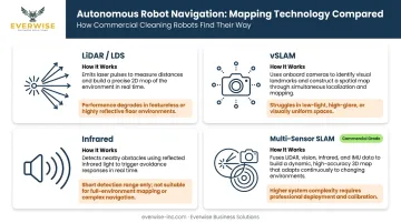
The underlying mapping process is similar across sensor types, but accuracy, cost, and performance in challenging conditions vary significantly:
| Technology | How It Works | Key Limitation |
|---|---|---|
| LiDAR / LDS | Emits laser pulses to measure geometry in 360° | Reflective or transparent surfaces can challenge returns |
| vSLAM (camera-based) | Tracks visual features to estimate position and build map | Can lose features under poor lighting or low-texture surfaces |
| Infrared | Detects proximity for basic obstacle avoidance | No persistent map storage; not true mapping |
| Multi-sensor SLAM | Fuses LiDAR, depth cameras, and RGB cameras | Highest accuracy; higher system cost |
Commercial-grade systems like Gausium's autonomous cleaning robots combine 3D depth cameras with AI for Intelligent Floor Identification — enabling the robot to detect floor surface type and adjust its cleaning mode automatically. Everwise Business Solutions deploys the full Gausium lineup across Texas, giving facilities buyers access to this multi-sensor capability without the integration complexity of sourcing hardware and support separately.
How Does Robotic Vacuum Mapping Work?
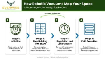
Robotic vacuum mapping runs as a sequence of four interdependent stages, each building on the last to produce a cleaning run that is systematic, repeatable, and continuously self-correcting.
Stage 1: Initiation — Starting the Mapping Process
The robot departs from its docking station, activates its sensors, and begins emitting signals to detect walls, furniture, and open floor space in its immediate vicinity. The dock serves as the fixed reference point: everything the robot learns about the space gets anchored to that origin.
Commercial robots typically initiate mapping in one of two modes:
- Dedicated mapping run: The robot explores the space without cleaning first, building the initial floor plan before any cleaning task begins. Common during first-time setup.
- Simultaneous mapping and cleaning: The robot builds and refines its map while actively cleaning, which is more efficient but produces a less complete initial map.
A few initiation dependencies matter in practice:
- Moving the dock after mapping begins can corrupt the floor plan
- Blocked doorways during the initial run create gaps in coverage the robot will never fill
- Consistent lighting conditions at setup benefit camera-based systems
Stage 2: Core Operation — Building the Map in Real Time
As the robot moves, its sensors continuously measure distances and angles to surrounding surfaces. Those measurements assemble into a coordinate grid — a 2D or 3D blueprint of the space — that updates thousands of times per second.
Most modern commercial robots use SLAM (Simultaneous Localization and Mapping) to manage this process. In plain terms, SLAM means the robot is doing two things at once:
- Localization — figuring out where it currently is within the space
- Mapping — updating the map based on what it's currently sensing
These two processes feed each other continuously. The map informs localization; localization informs the map. Research on multi-sensor mobile robot navigation has shown that sensor fusion can reduce cumulative localization error by over 45% compared to single-sensor approaches — which translates directly to more accurate floor coverage.
Map quality at this stage determines path efficiency downstream: a precise map enables straight-line systematic passes, while an imprecise map forces repeated overlap or leaves coverage gaps.
Stage 3: Regulation and Control — Staying Accurate on the Move
Even with accurate sensors, small errors accumulate. Wheel slippage, uneven floor surfaces, and sensor noise introduce positional drift over time. The regulation stage is how the robot corrects this.
The robot continuously cross-references its current sensor readings against its stored map. When it detects a discrepancy (say, it calculates three meters from the north wall, but sensors read two) it recalculates its exact position and corrects its heading.
Loop closure is the most powerful correction mechanism: the robot recognizes a location it has visited before, and uses that recognition to reconcile accumulated trajectory error across the entire map. Peer-reviewed LiDAR odometry research identifies loop closure as essential for long-range mapping accuracy — which is why it matters far more in large commercial facilities than in small residential rooms.
When unexpected obstacles appear (a cart left in a corridor, a person walking through a mapped zone) the robot:
- Detects the obstruction through real-time sensor readings
- Reroutes dynamically without stopping
- Flags or updates the affected zone depending on system sophistication
In large facilities with heavy foot traffic, a robot that cannot regulate its position in real time quickly diverges from its planned path. The Gausium Omnie is built for these high-dynamic environments such as hospital corridors during shift changes and retail floors during open hours, where the obstacle landscape changes constantly throughout the cleaning run.
Stage 4: Output — What the Robot Does With the Map
The mapping process produces a persistent, stored floor plan the robot references at the start of every subsequent cleaning session. No re-scanning from scratch. The robot arrives, loads its map, and starts cleaning immediately.
That stored map integrates into operations in several practical ways:
- Zone scheduling — assign specific areas to specific time windows (lobby at 6 AM, conference rooms at noon)
- No-go zones — restrict the robot from areas with equipment, fragile objects, or restricted access
- Coverage logs — document which areas were cleaned, when, and for how long
The Gausium Mobile App provides remote access to these controls across the lineup — monitoring cleaning tasks, managing schedules, and generating cleaning logs that support compliance documentation for Joint Commission, CMS, and OSHA surveys in regulated facilities.
A well-constructed map enables verifiable floor coverage, reduces session duration by eliminating redundant passes, and gives operators documented proof that cleaning occurred — which regulated industries increasingly require.
Where Robotic Vacuum Mapping Delivers the Most Operational Value
Mapping matters most where random navigation would produce unacceptable results. The environments where that's clearest:
- Hospital corridors and common areas — CDC guidance calls for structured environmental cleaning programs with objective monitoring. Mapped robots produce the cleaning logs that support that documentation.
- Hotel lobbies and back-of-house — Large footprints, varied surface types, and overnight scheduling requirements make mapped autonomous cleaning essential for consistent results without supervision.
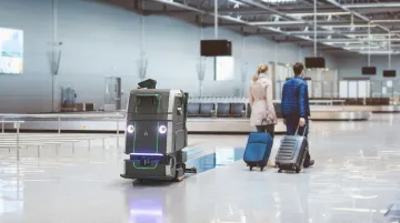
- Airport terminals and transportation hubs — Peak traffic, wide-open concourses, and 24/7 operations require robots that can navigate dynamically and cover large areas systematically.
- Warehouses and distribution centers — The Gausium Beetle cleaning 2,500 m² per day at 60% faster speed at Loulis Food Ingredients demonstrates what mapped systematic coverage delivers at scale in an industrial environment.
- Retail stores — Open-hours navigation with constantly moving shoppers and carts requires AI-powered dynamic mapping, not fixed-route systems.
Mapping Requirements Vary by Industry
The mapping capability a facility needs depends on its compliance requirements, floor type, and traffic conditions:
- Healthcare requires logged, verifiable coverage for compliance — and H13 HEPA filtration for infection control in common areas
- Hospitality needs quiet, scheduled overnight operation without manual supervision
- Manufacturing and warehousing requires robots that navigate around dynamic equipment and forklift traffic
Everwise Business Solutions deploys the full Gausium commercial lineup across Texas — San Antonio, Houston, Dallas, Austin, and the Rio Grande Valley — to match each facility type with the right mapping capability. That means:
- Gausium Omnie for high-dynamic environments with AI-driven navigation
- Gausium Scrubber 75 for large-area hard-floor scrubbing with high-precision SLAM
- Gausium Vacuum 40 for mixed-surface facilities requiring carpet and hard-floor coverage
Conclusion
Robotic vacuum mapping works because it replaces reactive, random movement with a persistent, sensor-built understanding of the space. The robot cleans systematically, corrects positional drift in real time, and improves its navigation with each session. The result is consistent, verifiable floor coverage — not an approximation of it.
For facilities buyers evaluating autonomous cleaning robots, suction power and battery runtime are secondary specs. The mapping technology is the core question: how the robot localizes, how it handles drift, how it manages dynamic obstacles, and what it does with the stored map. Those factors determine whether a robot genuinely covers the floor across every shift. For commercial operations in Texas looking to move from that understanding to an actual deployment, Everwise Business Solutions is the authorized Gausium distributor covering the state — with the full product lineup, on-site commissioning, and ongoing technical support to match the right robot to the right facility.
Frequently Asked Questions
Is mapping important for robotic vacuums?
Mapping is what separates systematic cleaning from random-path navigation. For commercial environments especially, mapped robots produce verifiable coverage and eliminate the missed zones that unmapped robots generate across large, complex floor plans.
Can you use a robotic vacuum without mapping?
Robots without mapping do exist, but rely on random or reactive navigation. That's acceptable for small, simple spaces — but unreliable as floor area and layout complexity grow, which describes most commercial facilities.
Which robotic vacuums support mapping?
Most mid-to-high-tier robots include LiDAR or camera-based mapping. Entry-level models typically use infrared obstacle avoidance without persistent map storage. Commercial-grade systems consistently include multi-sensor mapping with stored, reusable floor plans.
How long does it take for a robotic vacuum to map a space?
Mapping time depends on floor area and robot speed. Gausium's technology documentation notes approximately 30 minutes for an initial mapping run, though larger or more complex spaces will take longer. Subsequent sessions use the stored map and begin cleaning immediately.
How does a robotic vacuum update its map when the environment changes?
Advanced robots detect discrepancies between stored maps and current sensor readings during a cleaning run and reroute dynamically. Transient obstacles like people are handled in real time; permanent layout changes are reflected in the robot's stored map across subsequent sessions.
Is map data stored locally on the robot or in the cloud?
It depends on the manufacturer — some robots store maps onboard, others sync to cloud servers for app access and fleet management. Buyers in regulated industries like healthcare should verify data handling practices, encryption standards, and whether cloud features can be disabled before deployment.